Welcome to the Isle Royale Info site. This site is dedicated to providing information about Isle Royale National Park located in Lake Superior. It is meant to be a central point of reference for anyone wanting to go there, or just know more about Isle Royale.
"Half the fun is in the planning" Planning a trip to Isle Royale is not like planning a trip to most places and unlike planning a trip to any other National Park. You bring along most of the same things, but once you get there, there are very limited items available if any at all. You are basically left on an island with only what you have with you. In addition, the only way you can get there is via a boat or an seaplane. This involves what can seem like complicated logistical and schedule planning and is not something that can be done at the last minute. Because of this, planning a trip to the island can at first seem overwhelming. This makes it somewhere you cannot go unless you really want to go and are willing to spend the time learning and planning your trip. This also limits the people going there to those who are willing to do both. However, once you have gathered the information you need, it is just a bit more complicated than planning any other trip and the reward becomes that much better. Half the fun is in the planning!
This page is just a quick overview of the planning process and the steps involved. It is not a complete step by step "how-to" document and it is not meant to be. The island is a relatively large place with many trails, campgrounds and lakes. The routes to take are numerous and would take a whole book to describe. In fact, there is a whole book available from this site that will give you all of the information and complete details you need to plan a successful trip. There is also a program available to guide you through the process of planning your route and creating different scenarios. What follows is a quick synopsis of the steps involved and answers to common questions.
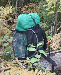
Step One: What to bring, what do I need? As mentioned above, you are pretty much on your own once you step off the boat with your gear. If you do not have something, you may not be able to get it there. There is a store in both Rock Harbor and Windigo that offer some basic items such as some kinds of fuel, meals, snacks and some limited camping supplies. The items vary and the stores are only open from approximately Memorial Day to Labor Day. The items are also expensive due to the cost of getting and stocking items on the island. With that in mind, you should try and bring everything you could possibly need and not rely on the stores for anything except for an item you might have forgotten. However, the idea is not to forget anything. This is a link to a suggested "Isle Royale Backpacking List" provided by the National Park Service in a PDF File. Click here and the suggested list will open in a new window. One thing that is just mentioned in this list that needs to be clarified is the "Water Filter". Rock Harbor and Windigo both have potable water, from approximately mid-May until mid-September. Besides there, all surface lake and stream water should be considered contaminated with natural parasites. At all of the designated campgrounds, there is a source of water, but it needs to be filtered or boiled. To purify your water, it needs to be passed through a 0.4 micron or less water filter. It can also be boiled, but should be at a rolling boil for at least 3 minutes, which requires fuel, time and does not taste too good. A UV type filter will NOT work.
There are two entry points on the island, Rock Harbor on the east side and Windigo on the west side. There are three ferry services running four different boats, out of three different cities, at various times of the year and on various days based on the time of the year. There is also a seaplane that operates to and from the island that can go to two different places on the island. As you can tell by these previous statements, it can be confusing. The first step in this decision is deciding where to get there from.
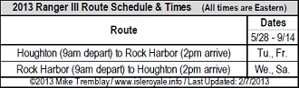
There is ferry service available from Grand Portage, Minnesota; Copper Harbor, Michigan and Houghton, Michigan. There is seaplane service available from Houghton, Michigan. As I said, they operate to different places on the island and run on varying days. Below is an overview of each of the services. The "Ranger III" is a vessel operated by the National Park Service. She leaves from Houghton, Michigan, goes to Rock Harbor, overnight's, and then returns the following day. She can be used to get to and from the eastern end of the island. Below is a sample of the schedule from 2013. To see a current schedule clickhere.
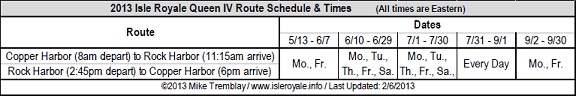
The "Isle Royale Queen IV" is a private vessel operated by the Isle Royale Line. She leaves Copper Harbor, Michigan, goes to Rock Harbor, docks for 3.5 hours, then returns to Copper Harbor. She can be used to get to and from the eastern end of the island. Below is a sample of the schedule from 2013. To see a current schedule click here.
The "Sea Hunter III" is a private vessel operated by Grand Portage-Isle Royale Transportation, She leaves Grand Portage, Minnesota, goes to Windigo, docks for 4 hours, then returns to Grand Portage. She can be used to get to and from the western end of the island. Below is a sample of the schedule from 2013. To see a current schedule click here.
The "Voyageur II" is a private vessel also operated by Grand Portage-Isle Royale Transportation, She leaves Grand Portage, Minnesota, goes to Windigo, then travels along the north side of the island with two potential stops on her way to Rock Harbor. She then overnights at Rock Harbor before traveling along the south side of the island, with three potential stops before docking at Windigo again, then heading back to Grand Portage. She is truly the "work horse" vessel on the island and can be used to get to most places on the island. Below is a sample schedule of the schedule from 2013. To see a current schedule click here.
The seaplane operates from the Houghton County Airport just north of Houghton, Michigan, by Isle Royale Seaplanes. It flies from mid-May through mid-September. It can hold up to 4 people and baggage is limited to 50 pounds per person, and you cannot bring your fuel on the plane. It will fly on-call up to six days a week and seven days a week during peak season, weather permitting. The trip typically takes less about 35 minutes and can land at either Windigo or Rock Harbor. For more information click here.
The cost for a one way ticket on any of the ferries is approximately between $60 and $70 to either of the entry points. The cost for the seaplane is bit more, running approximately $200 one way and $300 if you book it both ways. So, which service to take becomes a question of which place is best for you to leave from.
Once there, you can get around to other places as discussed in the next section.
Step Three: What do I do once I get there? - Part One Ok, so you have determined where you will be leaving from the mainland and where you will be arriving on the island. Now, you need to decide what to do once you arrive. This decision is just as hard, if not harder, than step two. There are over 165 miles of hiking trails on the island and 36 campgrounds on the island. In addition, just because you arrive at Rock Harbor or Windigo, that is not where you necessarily have to begin from. So, there is another decision to be made.
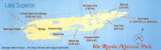
voyageur ii route and times. note: all times shown are central daylight time.
For example, if you arrive at Windigo either via Grand Portage, or the float plane from Houghton, you can go to other places along the north side of the island, or go all of the way to Rock Harbor (which would not make sense if you take the float plane as you can schedule it to Rock Harbor). If you take a look at the Voyageur II schedule, you can see it goes along the north shore with two stops after leaving Windigo. So, you can take a boat or the seaplane to Windigo and then go on to, for instance, McCargoe Cove and begin your trip there. Reversing that, you can also schedule a pickup along that route and get picked up at McCargoe Cove and get taken to Rock Harbor. So, considering this further, you can see that you can get dropped off at Windigo, or Rock Harbor and use the Voyageur II as a taxi to many points around the island. It just becomes a question of scheduling the different boats and their days.
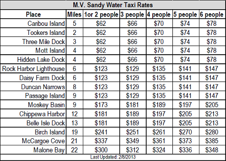
To further complicate things, or actually, make things easier (it depends on how you look at it), there is a water taxi service available through the Rock Harbor Lodge that can be scheduled to take you to various places. The chart below shows the places she can go and the rates for 2013. To see the current rates click here.
Step Three: What do I do once I get there? - Part Two Now, the big decision, what route do I take? This is by far the question I am asked most. This decision involves many variables. Among them, how many days do you have? How many miles do you want to hike in a day? What backpacking and/or paddling experience do you and the people going with you have? What do you want to do (ie. Hike, fish, relax). I am not going to be able to answer this for you. There are just too many routes and too many variables. This is something you will have to investigate and determine on your own. However, I have provided some tools to make it easier.
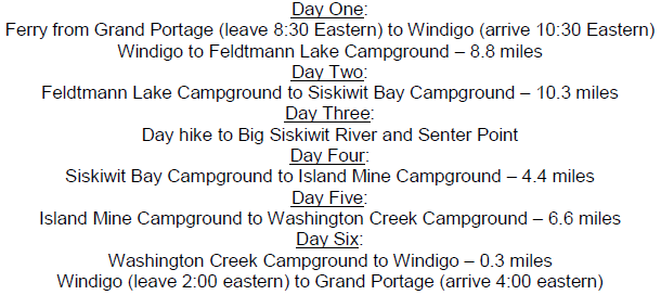
First of all, the "Isle Royale Info" book and related programs will give you information on all of the routes. The book details all of the trails, water routes, campgrounds and points of interest, plus details on what the island has and getting there. One of the programs included is the trip planner which is a program that displays all of the routes, mileage and difficulty in an easy to use concise manner for initial planning. Also included is a miles chart that displays the mileage from campground to campground for a quick reference to the distances. You can download a free demo version of the book and programs to try them out.
Besides the book, the most powerful tool available to plan your trip is the itinerary generator program. It will create and save an Itinerary based on your selections, allow you to load and view the itineraries you have created, create and print a permit based on it and generate a trip package with information on the trails and campgrounds on your route. When I am planning a trip, I usually make 3 or 4 posssible itineraries and compare the different routes. This program will create them for you and save them to compare different plans. Another item available are some trip packages which show various routes with possible itinerary's to compare. Once you decide on a route, you can purchase a package with all of the details on that route. You can also use some of these sample itineraries to give you an idea of ways to plan your route.
Step Three: What do I do once I get there? - Part Three There are some things to keep in mind when you are planning your route. The most common mistake I see people making (and I have done), is trying to cover too much ground in a short period of time. Being that the island is not easy to get to, the first thought in planning your route is to try and get to as many places as possible. The last thing you want to do is turn your trip into a "death march" to make sure you stay on schedule. This can quickly take away the joy of the trip for you and your partners. Just because you have created a schedule, it does not mean you have to follow it. With the amount of trails and campgrounds available, there is always an alternate route available based on conditions and how EVERYONE in your party are doing. I do not think I have ever done a trip where I exactly matched my planned itinerary. I have always changed it in one way or another based on different conditions. Another reason to not overdo it is the risk of injury. If injured in the backcountry, you are, at minimum, hours away from any kind of rescue and it could be a full day.
Closing: Half the Fun is in the Planning I hope this clears things up somewhat and does not just confuse you. As I said when I began this, it is not easy to get to Isle Royale, but worth it. The main thing to keep in mind is you need to do your research and be prepared before undertaking a trip like this. When I first started going to the island, I found that there was a lot of information available in various places, but I could not find one source. That is why I decided to write my book. The book provides detailed information in one place for most everything you could possibly need to go there. Good luck on your trip!
The "Suggested Backpacking list" is by the National Park Service from their website. The "Voyageur Route and Times" is courtesy of their website at: www.isleroyaleboats.com
This site is not affiliated with Isle Royale National park or any official or commercial organization. All information presented is to the best of my knowledge. All photographs and text are Copyrighted and may not be used in any form without permission.